
Over the course of two days at the beginning of the second week of July, Vermont and other parts of the Northeastern U.S. received more total rain than usually falls in two summer months. Coming on the heels of other recent rains that had saturated much of the ground, this precipitation went where gravity directed: right into streams, creeks, and rivers. When those waterways quickly reached their capacity, floodwaters spread out across low-lying farmland, residential neighborhoods, and commercial and downtown areas of cities and towns. Many culverts were no match for the flow, and roadways and bridges across the state were washed out. Vermonters awakened in the early morning hours of July 11 to find themselves in a changed state, challenged by the effects of the second “hundred-year storm” to hit the region in the last 12 years.
The Unoccupied Aircraft Systems (UAS) Team members of the University of Vermont’s Rubenstein School of Environment and Natural Resources’ Spatial Analysis Lab (SAL) had already been up for hours. A UAS –better known by most as a drone– provides an aerial perspective that can be crucial to response and recovery efforts. Jarlath O’Neil-Dunne, the Director of the SAL, was in San Diego on the 11th, about to walk into the plenary session of the conference he was attending, when a call came from a colleague in the Vermont Agency of Transportation informing him that UVM’s UAS services would be needed immediately. O’Neil-Dunne turned around, went to the lobby of the hotel and spent the rest of the day coordinating with his team back home, and with state agencies. By the time his redeye flight landed in Burlington the next morning, three UAS teams had been deployed on what would soon turn into the largest use of drones for disaster response and recovery ever carried out in the Northeast. As the team fanned out across the state, their eyes-in-the-sky returned images that showed extensive flooding across Vermont watersheds, in some places exceeding the records of 2011’s Tropical Storm Irene.
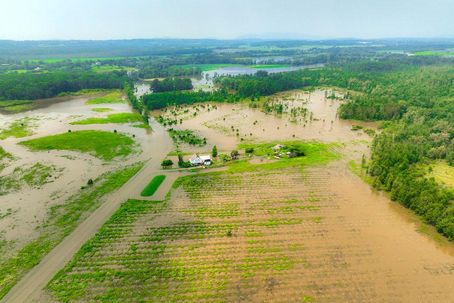
Drone image of a flooded farm in Middelbury, Vt.
Data with a Mission
UVM’s UAS Team was established in 2013 by O’Neil-Dunne to provide aerial data collection and analysis capabilities to assist transportation management, environmental assessment, asset management and, crucially, disaster response. It was founded in the aftermath of Tropical Storm Irene. At that time, when Vermont’s state government offices were flooded, the SAL took over coordinating the tasking, distribution, and analysis of satellite imagery. “We simply could not get the information to the people that needed it in a timely manner,” said O’Neil-Dunne. “We needed our own assets.” What started out as one drone and a student intern, would grow to be one of the nation's most robust and experienced UAS teams over the next decade. The SAL worked with every state in New England to establish and advance their drone programs. Their work would earn them national awards and the attention of then Senator Patrick Leahy who, seeing the potential drone technology had for disaster response, helped secure federal funding, which led to UVM joining ASSURE, the Federal Aviation Administration’s (FAA) Center of Excellence for UAS Research. Through the ASSURE efforts, UVM was able to catapult their drone work to the next level. “We were good at what we did,” says O’Neil-Dunne, “but working with our ASSURE colleagues across the nation accelerated our knowledge and capabilities beyond what we could have done alone.”
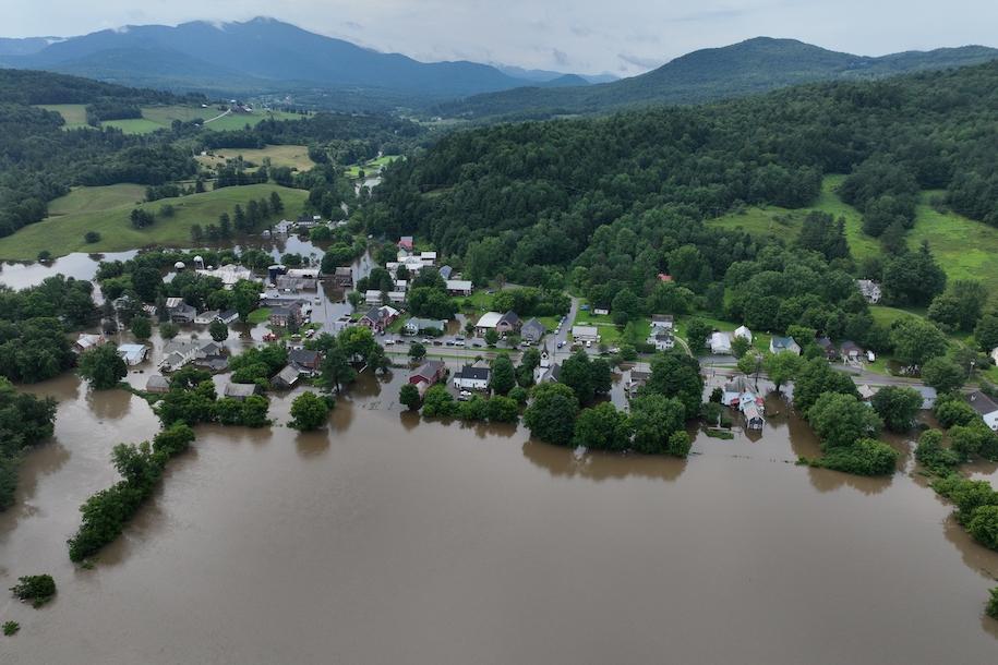
View of flooding in Cambridge, Vt., on July 11, 2023
The FAA-funded disaster response work would prove crucial when the floods hit on July 11. The team was able to tap into a wealth of operating procedures that enabled them to respond quickly and effectively. Another benefit of the research was that it funded the planning for a drone-focused disaster response exercise, originally planned for this August. With this exercise in mind most of the key organizations involved in the July flood response had been in planning meetings in the early part of the summer. “This was the disaster we hoped would not happen, but we could not have been better prepared,” said O’Neil-Dunne. Coupled with this was a series of drone training workshops the SAL offered for state agency personnel over the past five years. The result was that the UVM team, the Vermont Agency of Transportation, and State Police drone operators know each other personally and have developed trust. Collaborations with the Vermont Center for Geographic Information (VCGI) and FEMA led to a drone data viewer being stood up within 24 hours of the event, providing a common operational picture for the response efforts.
“None of this would have been possible if we did not have strong working relationships,” said O’Neil-Dunne.
From the start of their efforts, SAL staff saw that, in addition to water, time was another adversary. “We knew that it was crucial that we capture the conditions near peak flood,” said O’Neil-Dunne. Without peak flood evidence, the Federal Emergency Management Agency (FEMA) would have to send in damage inspectors, which would delay the release of recovery funds.
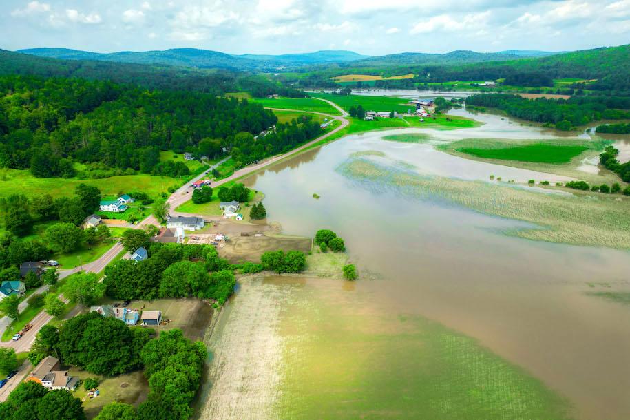
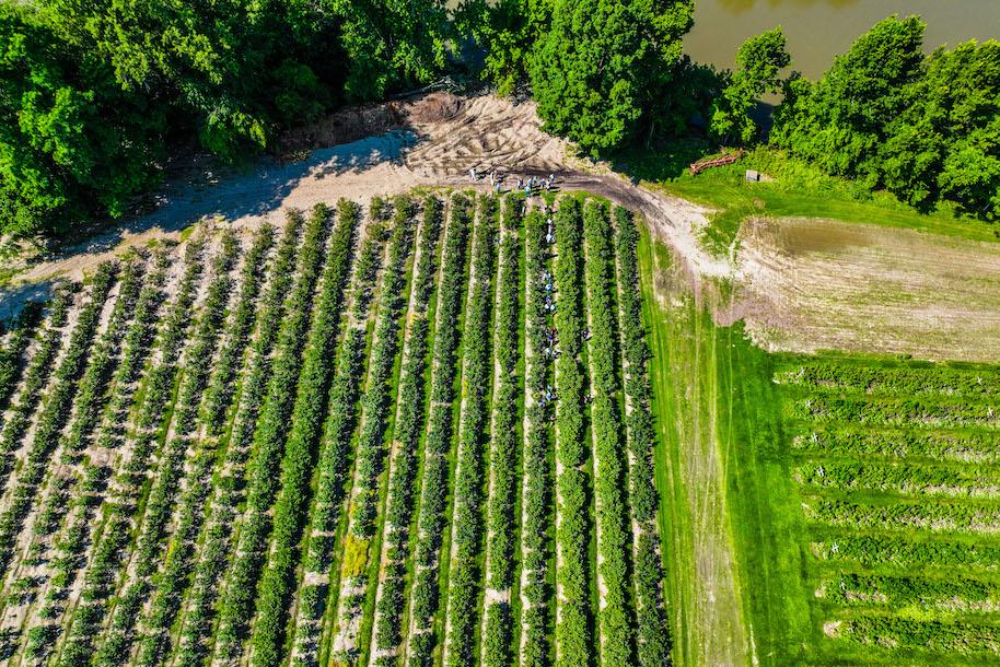
Flooded farms near Jeffersonville, Vt.
“We realized that we had a limited time to acquire data near peak flood levels, so we knew we had to move quickly,” said O’Neil-Dunne. The teams were forced to operate in challenging environmental conditions, with a great degree of uncertainty, and under tremendous pressure. O’Neil-Dunne is quick to credit his team for the success. “There was a time when I was the technical expert. That is no longer the case,” he said. “Our staff and students are incredibly good at what they do. It’s not just operating the drones, but making split-second decisions that make the difference between mission failure and success.” The UVM teams deployed specialized drones, which unlike most, are approved to operate over people, worked with the FAA to obtain authorization to fly in areas where drones are typically prohibited, and operated advanced laser scanning equipment to map landslides through trees. “These are not skills that you pick up in a few weeks,” said O’Neil-Dunne, “our team has been working at this for years.” He continued, “it takes tremendous competency to operate a drone worth over $100,000 when flood waters are rising behind you.”

A UVM UAS drone captured this view of a damaged road in Hardwick, Vt. on July 15, 2023.
A critical task for FEMA was securing fast, reliable damage assessment. The SAL was by far the largest supplier of the accurate, mapping-grade imagery that the agency could use for work that would ultimately provide recovery funds to hard-hit Vermonters. Estimates are that the release of assistance funds crucial for individuals to recover were sped up by weeks because of the SAL’s work. “It is a privilege to be able to help our home state during a time of need,” said team member Lauren Cresanti, who received her environmental sciences degree from UVM this past May. Cresanti started as a drone intern in the SAL two years ago, honing her skills using advanced sensors to map forest defoliation from spongy moth caterpillars. Those skills proved crucial in the response effort in situations where traditional cameras were not suitable. Cresanti led missions in Barre and Ripton, mapping landslides, using a drone-based laser scanner that could penetrate tree canopy. Meanwhile, her colleagues were flying advanced cameras that can detect light that humans cannot see to provide evidence of crop damage to speed the release of recovery funds for farmers.
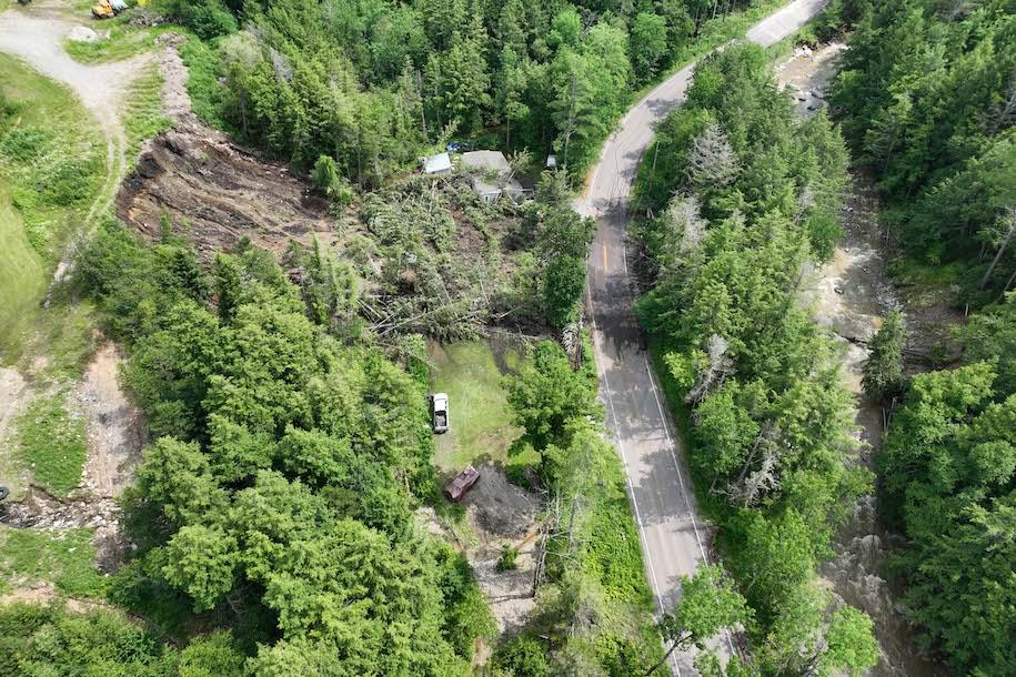
Drone-captured image of a landslide in Ripton, Vt. on July 15, 2023.
Covering the State
The SAL’s UAS teams logged 15-hour days recording conditions in areas from Cambridge and Jeffersonville on the Lamoille River, to Richmond, Waterbury and Berlin in the Winooski watershed. Work in central Vermont included recording damage to mobile home parks that may help affected residents receive aid. Back on campus, teams of analysts worked behind the scenes to process and disseminate the data to local, state, and federal agencies via web apps.
In the days following, the team deployed to survey the hard-hit city of Barre, where they worked in close collaboration with staff from Vtrans and the Vermont State Police. Together they provided search and rescue assistance and mapped extensive areas of the flood-ravaged city in the course of one afternoon.
“This group practiced joint operations several years ago, and it paid off,” said O’Neil-Dunne. “It was the largest drone operation in state history. City officials were beyond thrilled with the help we provided.”
A survey team also covered the flooded Otter Creek near Middlebury, and were called in to assess damage from a landslide in Ripton, one of the largest of nearly 50 landslides across Vermont that were triggered by the initial storm and further rainfall in the week afterward.
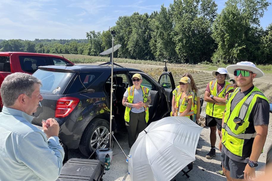
Vermont Secretary of Agriculture, Food and Markets Anson Tebbets speaks with the UVM UAS Team in the field.
The UAS Team
The entire team of drone operators consists of either staff who graduated from UVM or current students. This home-grown approach paid off immeasurably in the flood response. The team pulls from majors across campus, including natural resources, engineering, anthropology, and agriculture. Just as important as the breadth of academic credentials is the diversity of the individuals. The team includes student veterans, international students, and while over 90 percent of registered drone pilots nationally are male, the majority of UVM’s identify as non-male. “Diversity is key,” said O’Neil-Dunne, “In uncertain situations, when the stakes are high, we need different ways of thinking. Our team’s diverse background gives them the ability to problem solve in challenging environments.”
Another team resource was the Rubenstein School’s Ford F-150 Lightning electric vehicle, which entered service this past year. The pickup truck not only delivered team members to hard-to-access areas but also helped keep their drones in running order.
“Drone batteries are the fuel on which we run, and the electric truck charges them in no time,” said O’Neil-Dunne.
The team’s unique data helped support President Biden’s July 14 Major Disaster Declaration, and weeks after the initial rainfall, the UAS team continues to aid the response to flooding – mapping landslides, tracking streambed erosion, and detailing the evidence Vermont farmers will need to obtain relief funds. All told, the UAS team has flown well over 100 missions in this effort and captured more than 20,000 images.
UVM researchers and administrators visit the Mazza farm in Essex on July 24, 2023. Drone imaging and analysis post-flooding gives farmers and disaster relief officials crucial information about crop damage and the health of surviving crops.
Their work continues. Postdoctoral student Paige Brochu has completed a rapid drinking water assessment for the use by the Vermont Department of Health. Two staff research analysts, Cale Kochenour and Terry Barret, worked with the USDA using satellite imagery to assess crop damage to Vermont’s farms. Drone surveying will also play an important role in the rebuilding process now underway. The team has been told to expect continued operations until at least mid-November.