


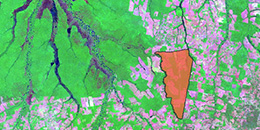
The recent availability of high spatial resolution (detailed) satellite and aerial imagery, desktop and online software for Geographic Information Systems (GIS), Remote Sensing (RS), and inexpensive Global Positioning Systems (GPS) have driven geospatial technologies to the forefront of a revolution in acquisition, integration, and analysis of geospatial data. These data can be applied to a wide array of environmental issues at local to global scales. The tools offered by these technologies can incorporate huge volumes of data from many sources tied to a location on the Earth and analyze that data using new and innovative methods to reveal relationships in time and space.
Welcome to Geospatial Technologies at UVM. Here you will find information on getting started using geospatial technologies, accessing software, finding data, selecting courses, obtaining technical help, learning about research projects, and more.

Academics
UVM offers a range of GST courses which may be used to obtain a GST minor or a professional certificate. Find out more about the curriculum, courses, advising, how to apply, and other FAQs.

Research
At UVM, faculty, staff, and students conduct a myriad of research using GST. Find out more about the research we do within the university as well as our involvement with the broader community and other partners.
Resources
UVM has a number of resources for those involved with GST. We provide access to scholarship opportunities, internships, software, Vermont Advanced Computing Core (VACC), data sources, and other help.