
 |
 |
|
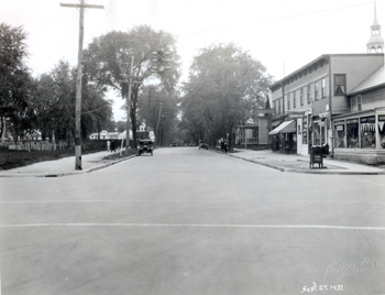
Southerly view of Elmwood Avenue from intersection at North Street, L.L. McAllister, September 27, 1931 In this image, one can see the street after it has been repaved, and a traffic light placed at the busy intersection. On the left of the image, one can see the full length of the Cemetery, from North Street to Grant Street. On the right, numbers 139 and 141 are visible behind Elmwood Avenue’s commercial center, numbers 143 through 151. Also visible on the far right is part of Turner's drug store, number 201 North Street. Little else beside street improvements changed between April and September of 1931.
|
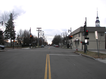
Southerly view of Elmwood Avenue from intersection at North Street, Kurt Jergensen, October 18, 2005. UTM coordinates: 0642027, 4927305 (NAD 83). As stated in the comparison of the previous image, the most significant change to any of the features in this image happened to the commercial block, which was replaced in 1977 by the structure that stands today. The gable-fronted residence at number 141 was also replaced by a raised ranch style apartment building in 1963. [1] The same minor infrastructure changes visible in the previous image can be seen here. Fortunately, some important landscape features have not changed, such as the cemetery and the steeple of St. Joseph's Cathedral, which provide clearly matched borders to the image that can be compared.
[1] City of Burlington, Vermont: Assessor's Office.
|
|
< Previous · Bibliography > L.L. McAllister's Elmwood Avenue Photographs Historic Burlington Project |