
 |
 |
|
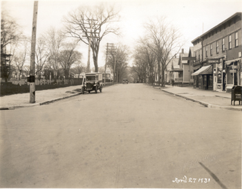
Southerly view of Elmwood Avenue from intersection at North Street, L.L. McAllister, April 27, 1931 In this image, one can see the street before it has been paved. On the left of the image, one can see the full length of the Cemetery, from North Street to Grant Street. On the right, numbers 139 and 141 are visible behind Elmwood Avenue’s commercial center, numbers 143 through 151. Number 139 and 141 have both been single-family dwellings since they were built. Though the exact date of construction is unknown, there have been structures on the site since circa 1872, by their appearance on the 1877 bird’s eye view of Burlington, but not the 1869 Beers map.[1] These two two-story gable front dwellings are much like those constructed near Grant Street in appearance, and it is possible that they are of the same era. They had each housed only a few residents prior to the time of the photograph, though these residents covered a wide spectrum of Burlington society, from doctors to postal workers to auto salesmen.[2] Numbers 143 through 151 Elmwood are a series of two and a half story flat roofed Italianate commercial structures. The first floor in each section has always been devoted to commercial uses, while the second is residences for the shop owners. Number 143 Elmwood was most likely constructed as an apothecary shop circa 1885. The first owners of the shop were DeNoel and Bourbonnais, who began advertising their new location in 1889. The shop went through several different owners between 1892 and 1896, when Treffle Duhamel moved his business to Elmwood Avenue from Church Street. Duhamel operated the drug store for many years, leaving it to employee John B. Lambert after his death in 1913. Lambert’s Pharmacy continued to occupy the shop when McAllister took his photos of the area.[3] Number 145 has been put to many uses, from a shoe store to a barbershop and cleaners. For a period of three years, from 1903 to 1906, numbers 145 and 147 were both used as a bakery and bakeshop by J.A. Gingras. For the next nine years following, Joseph Bergeron and Henry Charron devoted the shop to the plumber’s wares and services. At the time of the photo, The Cloverdale Company occupied the shop.[4] Number 147 had served primarily as a residence and painter’s shop since 1906. From 1912 to 1931, Edgar Spaulding, a painter, used the shop space to conduct his business, and, presumably, rented the living space on the second floor. In 1931, John McQuaid, owner of Clarey’s Lunch next door, was using the residential space.[5] Number 149 appears to have been divided off from number 151 around 1911 by its owner, Herman Bloomberg. Bloomberg operated his shoe repair business there until 1913. The shop stood vacant for two years, and then was bought by barber Ernest Young. Young worked there for two years before selling to Elmwood Cash Market, which operated until 1928. The shop was then bought by John McQuaid and operated as Clarey’s Lunch restaurant.[6] Number 151 does not appear in city directories prior to 1905. It is uncertain at this time why that is, as it is listed as a residence on earlier Sanborn maps. In 1905, Herman Bloomberg is recorded to operate a shoe repair business on the premises, which he continued to do until he divided the shop space, creating number 149 in 1911, when he moved. Following Bloomberg’s removal to number 149, the shop passed through many owners, from the City Remnant Store, to a confectionary, to a ladies clothing store. William Deguise was using the space as a barbershop in 1931.[7]
[1] 1869 Beers Map of Burlington, 1877 Bird’s Eye Map of Burlington and Winooski [2]Burlington City Directories, 1901 - 1931 [3] Burlington City Directories, 1866 - 1931 [4] Burlington City Directories, 1901 - 1931 [5] Burlington City Directories, 1901 - 1931 [6] Burlington City Directories, 1911 - 1931 [7] Sanborn Fire Insurance Map for Burlington, 1894. Burlington City Directories, 1904 - 1931
|
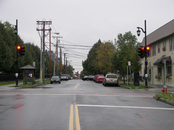
Southerly view of Elmwood Avenue from intersection at North Street, Kurt Jergensen, October 18, 2005. UTM coordinates: 0642030, 4927294 (NAD 83). The most significant change to any of the features in this image happened to the commercial block. Though the reason is unclear, it appears that the former structures were removed in 1977 and replaced with what we see now, according to the Assessor's Office. The structure continued to house several different businesses for a few years, before becoming a tavern. Beside the removal of the Italiante commercial block, the gable-fronted residence at number 141 was replaced by a raised ranch style apartment building in 1963. This structure is set back from the street, to allow parking in front, and so it is obscured by T. Rugg's Tavern[1] Along with the drastic changes to numbers 141 through 149, minor infrastructure changes have taken place at this important intersection. New traffic lights, street lighting and a bus stop have been added. However, one infrastructure component that existed in 1931 is noticeably absent: the mail box. Clearly, it was no longer needed at the corner of North Street and Elmwood Avenue when the Federal Building, with its post office, was built just down the street.
[1] City of Burlington, Vermont: Assessor's Office. http://www.ci.burlington.vt.us/assessor/search/. December 2, 2005.
|
|
L.L. McAllister's Elmwood Avenue Photographs Historic Burlington Project |