Course Syllabus
The Changing Face of Vermont Landscapes
Examination of Vermont's changing landscapes through the interpretation of historic images. Emphasis on the interaction between geology, geologic processes, and human endeavors and societies.

Instructor: Dr. Paul Bierman, Professor of Geology and Natural Resources
3 credits – on-line
GEOL 196
Continuing Education Winter Term (and a little bit of spring :)
starts December 23, 2008
Description
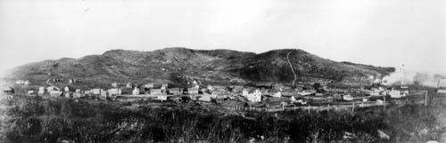
Vermont prides itself on its breathtaking natural landscapes:
for more than one hundred years, tourists have flocked here to see
these landscapes, residents enjoyed small-town and rural lifestyles,
and students of all ages learn by experiencing the Vermont landscape.
But the landscapes we see today have not always looked the same. Using
historic photographs we can glimpse the past, seeing Vermont as it was.
The landscapes captured in historic images can help us understand
change in Vermont and inform contemporary decisions about land use and
its impacts on the environment.
This on-line course will provide you with the tools to
understand landscapes through the analysis of historic images. Although
the course will be almost entirely on-line, there will be the
opportunity for
students and faculty to exchange ideas through email and web-based
interactions. The course consists of a series of modules to be
completed in sequence and by certain due dates. You will conclude the
first part of the course by creating an interpretive PowerPoint
presentation of images,
selected from the archive, that tells a story either of a place through
time or of a process shaping the Vermont landscape - a module. The
course is
structured so that peer review of your work happens several
times. The second part of the course is independent work that
will continue over the spring term. It will involve relocating
and rephotographing historic images and then describing the changes you
observe.
We will begin with an overview of the geologic forces and events that have shaped the Vermont landscape. Then, we'll use an ever-expanding community archive of Vermont historical imagery, the Landscape Change Program, as the catalyst for our work. Using this UVM-based archive (http://uvm.edu/landscape), we will practice describing and interpreting historical images, as well as learning the technology needed to find and download images from the archive.
During the first two weeks (winter term), prepare to spend
about 12-18 hours working on line, completing
modules, answering study questions, and doing downloads related to the
class modules. You should expect about 20 to 25 hours of homework
time--reading, interpreting images, and creating and revising your
personal interpretive PowerPoint presentation. During spring
term, be prepared to spend 20-25 hours in total, finding,
rephotographing, describing, and uploading your images.
There are no prerequisites for this course other than an interest in landscapes.
The course is designed so that by its completion, you should be able to:
- Easily and quickly use the Landscape Change Program to find images of Vermont landscapes
- describe and interpret Vermont Landscapes, their history and origin
- describe historical images
- recognize and describe human impact on the landscape and the impact of the landscape on human endeavors
- apply these newly learned skills in image interpretation, digital imagery, and computer use to create an interpretive PowerPoint presentation that tells a story important to you, examining either a topic in landscape history or the landscape history of a place over time
- experience critical review of your work and the revision and improvement process that follows
- relocate, rephotograph, geolocate using GPS the sites of
old images and then describe landscape changes that have occurred
Requirements are listed at this link:
http://learn.uvm.edu/?Page=online_equipment.html
Optional textbook: Suggest that you consider buying or borrowing: Albers J., 1999. Hands on the land: a history of the Vermont landscape. MIT Press, Cambridge, MA.
Grading
40% on-time completion of assignments for modules 1 to 7 and 9
15% on time submission and quality of draft PowerPoint presentation
15% on time submission and quality of final PowerPoint
presentation
30% on accurate rephotography, GPS measurement, description,
uploading and analysis of new images over spring term.