Vermont Barn Census
Chittenden County Student Research Project - 2010
Burlington and South Burlington Censuses
...
History of Burlington and South Burlington New Hampshire Governor Benning Wentworth, under King George III, granted a charter to Samuel Willis and sixty-three others in 1763 to set up the township of Burlington.(1) The charter, similar to the charters of several other Vermont towns, required the grantees to “improve five acres of land for every fifty acres owned by them.”(2) This required the presence of agriculture and growth in the newly formed township. The town, which presently is part of Chittenden County, was 23,040 acres and situated with Lake Champlain to the west, Colchester to the north, Williston to the east and Shelburne to the south. In 1794, the land east of the Muddy River was annexed to Williston by an act of legislature and the make up of the town was again altered on January 18, 1865 when it was voted that “all the township lying west of an irregular line drawn from the mouth of Shelburne Bay, northeasterly through the center of the township to the Winooski River,” would be incorporated into the City of Burlington. All of the “residue” would then be known as South Burlington.(3) The agriculture in both the City of Burlington and the Town of South Burlington can only adequately be explained through an examination of the histories of both.
History of Burlington Township
Burlington was first chartered in 1763 but actual settlement of the town was delayed by the start of the Revolutionary War. The first settlement was not established until 1783, when Steven Lawrence moved his family to the area followed by others in the same season. The town was organized and the first town meeting on record was held March 19, 1787.(4) The first store was erected in 1789 and had increased to six by 1800. In 1791, the University of Vermont was chartered and this brought an increase of population to the area. By 1824, Burlington boasted eighty-seven retail and mercantile structures including a saw mill, grist mill, wool factory and a glass factory.(5) Beyond the industrial changes Burlington was undergoing, the area was known for its dairy farming. According to the 1860 Agricultural Census there were about 111 farms in Burlington with their major produce being cheese and butter. There were small outcroppings of sheep farmers, the most prosperous among them being John and Edward Van Sicklen who produced 2600 pounds and 430 pounds of wool from their farms, respectively, in the year 1860.
Burlington began to alter once it was incorporated as a city in 1865. Burlington lost 10,400 acres of low flat land to South Burlington in the split and with it a majority of its farmland.(6) In the 1870 Agricultural Census Burlington had 54 farms left, half of their number in 1860. It is notable that the individual values of the farms increased. Land in Burlington was now a commodity. Even the farmland used by the University’s Agricultural Department was divided up into lots for the construction of other academic buildings. The University eventually bought Hoag Farm in South Burlington as the new research complex.(7) Burlington continued to industrialize and focused less on agriculture. The 1880 Agricultural Census had 46 farms, continuing the downward trend until the 1945 Farm Census did not even mention Burlington in its findings.
Tangential History of South Burlington
As Burlington began to grow and move towards mills, mercantile ventures and retail South Burlington thrived on dairy farming. South Burlington Farms were affected by Burlington growth only in the respect that new homes were being built in the area for men working in Burlington. Some farmers found it more profitable to cut up their acreage into building lots for these new homesteads.(8) Other than that, South Burlington’s economy continued to be based on its dairy farms well into the 1950s.
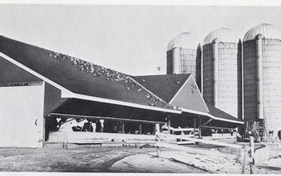
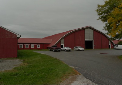
The Van Sicklen’s, who were successful sheep farmers in 1860, followed the trend of most sheep farmers in Vermont. After the Civil War, it was extremely difficult to turn a profit from selling wool and the 1870 and 1880 South Burlington Agricultural Censuses show that the Van Sicklen’s no longer owned any sheep at all and instead ran dairy farms. Butter, milk, and cheeses were the main produce of the area. The Hoag Farm was bought to provide students from the University of Vermont with a place to learn about dairy farming. Presently called the Paul Miller Research Complex (see Figure 1 and 2), the farm provides a working dairy farm in South Burlington with the added benefit of education.
 |
 |
| Figure 1. Paul Miller Research Complex, 1975 Courtesy of Ann B. Wetzel, et.al, A Look Around South Burlington, Vermont (Burlington, VT: Chittenden County Historical Society, 1975), 12. |
Figure 2. Paul Miller Research Complex, 2010, Photo Courtesy of Meredith Maus |
The number of farms held fairly steady over the years with one hundred and four in 1870, eighty-eight in 1880, and one hundred and twenty-two in 1945, according to their respective Agricultural Censuses. The landscape of South Burlington began to change in the 1950s. Interstate 89 was built and cut across South Burlington. Plans for the erection of the interstate’s clover shaped exit in South Burlington conflicted with the presence of an old saltbox farmhouse from the 1800s. The town was given the chance to buy the structure but nobody was interested and the farmhouse wound up being destroyed in favor of Suburbia.(9) This scenario served as a template for how interactions between South Burlington barns and urban sprawl would play out for the rest of the century.
Current State of Farms and Barns in Burlington and South Burlington
Few barns remain in the City of Burlington. Even less continue to turn a profit or produce farm goods at all. In Burlington, a majority of the farms operate as community gardens. The Intervale, in particular, is a good example. The Intervale is located in the northern part of Burlington and has been described as having a fertility that is “not surpassed by any [land] in the state.”(10) The land has had a rough history; it was completely flooded in the Vermont Flood of 1927 (see Figure 3), and then it was used as a dumping ground mid-twentieth century, until it was finally bought in 1986 and returned to its original agricultural purpose after some serious rehabbing.(11) There are presently twelve different farms in the area offering produce ranging from pumpkins to berries. The produce from these farms are sold at farmer’s markets and other local venues for the citizens of Burlington.
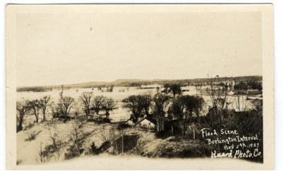 |
| Figure 3. Flooding of the Burlington, Vermont Intervale, 1927 Photo Courtesy of Bailey Howe Library: Special Collections UVM |
Community gardens are also present in South Burlington though to a lesser extent. South Burlington still has privately owned farms that operate on a daily basis; however, the present economic base of South Burlington is derived “primarily from sales, service and construction industries.”(12) Despite the presence of urban sprawl, farmland is only a mile or two away, on the outskirts of the shopping malls and supermarkets. The University of Vermont still owns farms in South Burlington, some they continue to operate like the Paul Miller Research Complex and others they maintain as storage space rather than their original intention.
...
1 Hamilton Child, “City of Burlington,” Gazetteer and Business Directory of Chittenden County, for 1882-1883 (Syracuse: Hamilton Child, 1882-1883), 94.
2 W.S. Rann, ed. “City of Burlington,” History of Chittenden County Vermont: with illustrations and biographical sketches of some of its prominent men and pioneers (Syracuse: D. Mason and Co. Publishers, 1886), 394.
3 Child, Gazetteer and Business Directory of Chittenden County, 94.
4 Austin James Coolidge and J.B. Mansfield, A History and Description of New England: General and Local (Boston: Austin J. Coolidge, 1859), 765-66.
5 Zadock Thompson, A Gazetteer of Vermont; Containing A Brief General View of the State (Montpelier: E.P. Walton and Zadock Thompson, 1824), 85.
6 Know Your Community: South Burlington, Vermont 1865-1977 (Published by the South Burlington League of Women Voters), 3.
7 Ann B. Wetzel, Betty Bandel, and Frances Myers, Look around South Burlington,
Vermont (Burlington, VT: Chittenden County Historical Society, 1975), 12.
8 Ibid., iii.
9 Ibid., 32.
10 Thompson, A Gazetteer of Vermont, 84.
11 “Intervale,” <www.intervale.org>
12 Know Your Community, 5.