
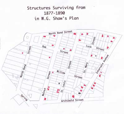
During the late 1800s, the Shaw family sold their farm land, succumbing to the rise in urbanization in Northeastern cities. The land sold created Willow Street, Oak Street, St. Mary’s and St. Louis Streets, Luck Street and Walnut Streets. During this period of industrialization, factory development increased and so did the demand for housing for immigrant French Canadian, Irish and German workers. Streets in the North End began to fill with Queen Anne style housing.[1]
The gable front houses, which make up the majority of the houses built between 1877 and 1890 in Burlington’s North End are an ideal size for the narrow urban lots found in Shaw’s Plan. Like other areas in the Northeastern region of the United States, Burlington is home to a particular vernacular style in this form. Most in the Shaw Block are narrow, one and a half or two story houses with steep roof pitches and raking eaves. Most are free of ornamentation, though several of the houses have at least one distinguishing feature.
Photographs in this study were taken by the author.
[1] Vermont Historic Sites and Structures Survey. Vermont Division for Historic Preservation, 1978 and 1983. Found at University of Vermont Library, Special Collections, and also on CD at University of Vermont, Vol. 127.