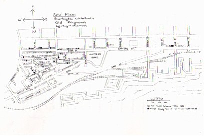
Waterfront and the Old Fair Grounds Area of the Old North End
Mary Stadalnick
Much of the Old North End of Burlington was built in direct response to the booming lumber industry that took place after the Civil War. By 1873, Burlington, Vermont was the third largest lumber port in the United States and the industry required almost 1,000 employees to sustain it.[1] The Chittenden County Fairgrounds, which appeared on the 1869 Beer’s Map, were taken over for new housing by 1870. Most of the houses built in the Old North End of Burlington were vernacular structures built with little of the high style detailing one finds in the hill section of Burlington. Many of the owners of houses in Burlington’s Old North End rented either apartments within their houses or else rooms to laborers being employed at Burlington’s waterfront.
The growth in Burlington’s industry at this time is in large part due to the excellent transportation corridors to and from the city of Burlington including the railroad, steamships, and canals, which helped to allow the waterfront’s industries to develop and grow. The lumber industry in Burlington produced one hundred and twenty million feet of lumber in 1870 with a value of $2,847,316.[2] Other industries in the Burlington area included cotton mills, woolen mills and other businesses one might expect to find in a prosperous city. The growing commerce in the Burlington area brought about a large population increase and the need for new housing. Many residential houses in Burlington’s Old North End were built at this time for the influx of new workers who helped to develop and support the emerging lumber manufacturers and other industries in the city of Burlington.
[1] 1871-1872 Burlington City DirectoryIndex of Sites
186 PARK STREET 216 PARK STREET